


Luxembourg

claudel
User
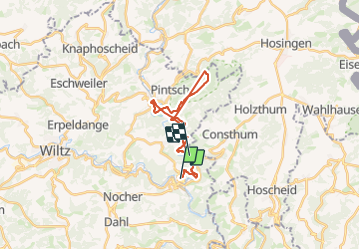

Length
18.2 km

Max alt
458 m

Uphill gradient
707 m
Km-Effort
28 km

Min alt
259 m

Downhill gradient
711 m
Boucle
No
Creation date :
2023-10-18 08:23:49.643
Updated on :
2023-10-18 14:01:22.661
5h36
Difficulty : Very difficult

FREE GPS app for hiking
 SityTrail
IGN / Geographical institutes
SityTrail Plus
The world is yours!
About
Trail Walking of 18.2 km to be discovered at Unknown, Canton Wiltz, Kiischpelt. This trail is proposed by claudel.
Positioning
Country:
Luxembourg
Region :
Unknown
Department/Province :
Canton Wiltz
Municipality :
Kiischpelt
Location:
Unknown
Start:(Dec)
Start:(UTM)
286144 ; 5537798 (32U) N.
Comments