


Lardy - 13,1 km - 3h30

Bastet
User
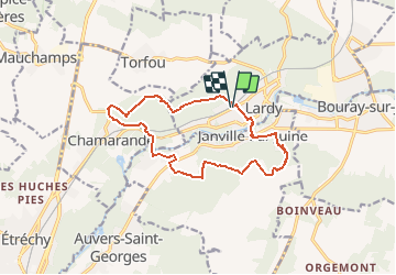

Length
12.9 km

Max alt
162 m

Uphill gradient
228 m
Km-Effort
15.9 km

Min alt
60 m

Downhill gradient
227 m
Boucle
Yes
Creation date :
2018-05-13 00:00:00.0
Updated on :
2018-05-13 00:00:00.0
3h30
Difficulty : Easy

FREE GPS app for hiking
 SityTrail
IGN / Geographical institutes
SityTrail Plus
The world is yours!
About
Trail Walking of 12.9 km to be discovered at Ile-de-France, Essonne, Lardy. This trail is proposed by Bastet.
Description
Cette randonnée vous permettra de découvrir les différents sites et points de vues remarquables autour de Lardy, à travers champs et bois, aux abords de la Juine au cours tranquille.
Positioning
Country:
France
Region :
Ile-de-France
Department/Province :
Essonne
Municipality :
Lardy
Location:
Unknown
Start:(Dec)
Start:(UTM)
445029 ; 5374420 (31U) N.
Comments