


Trail avec les 🦌🦌🌞

J-Mi
User
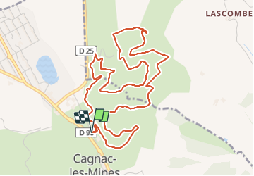

Length
6.7 km

Max alt
365 m

Uphill gradient
124 m
Km-Effort
8.3 km

Min alt
288 m

Downhill gradient
125 m
Boucle
Yes
Creation date :
2023-10-19 07:24:44.935
Updated on :
2023-10-19 09:03:15.303
0m
Difficulty : Medium

FREE GPS app for hiking
 SityTrail
IGN / Geographical institutes
SityTrail Plus
The world is yours!
About
Trail Trail of 6.7 km to be discovered at Occitania, Tarn, Cagnac-les-Mines. This trail is proposed by J-Mi.
Description
Longueur 6,7 KM avec 160m de D
Positioning
Country:
France
Region :
Occitania
Department/Province :
Tarn
Municipality :
Cagnac-les-Mines
Location:
Unknown
Start:(Dec)
Start:(UTM)
430881 ; 4871185 (31T) N.
Comments