


depart cimetiere d'Archelange vers Dole

gerardmicheline
User
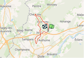

Length
21 km

Max alt
346 m

Uphill gradient
447 m
Km-Effort
26 km

Min alt
205 m

Downhill gradient
448 m
Boucle
Yes
Creation date :
2023-10-19 09:41:20.296
Updated on :
2023-10-19 09:42:03.511
6h01
Difficulty : Very difficult

FREE GPS app for hiking
 SityTrail
IGN / Geographical institutes
SityTrail Plus
The world is yours!
About
Trail Walking of 21 km to be discovered at Bourgogne-Franche-Comté, Jura, Archelange. This trail is proposed by gerardmicheline.
Positioning
Country:
France
Region :
Bourgogne-Franche-Comté
Department/Province :
Jura
Municipality :
Archelange
Location:
Unknown
Start:(Dec)
Start:(UTM)
690616 ; 5224014 (31T) N.
Comments