


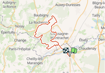
Chagny-Chassaigne-st aubin-santeney

XavierFaidix
User

Length
32 km

Max alt
496 m

Uphill gradient
706 m
Km-Effort
41 km

Min alt
204 m

Downhill gradient
705 m
Boucle
Yes
Creation date :
2023-10-19 06:56:55.723
Updated on :
2023-10-19 12:07:49.299
3h15
Difficulty : Medium

FREE GPS app for hiking
 SityTrail
IGN / Geographical institutes
SityTrail Plus
The world is yours!
About
Trail Mountain bike of 32 km to be discovered at Bourgogne-Franche-Comté, Saône-et-Loire, Chagny. This trail is proposed by XavierFaidix.
Description
des singles confidentiels et joliment techniques
Positioning
Country:
France
Region :
Bourgogne-Franche-Comté
Department/Province :
Saône-et-Loire
Municipality :
Chagny
Location:
Unknown
Start:(Dec)
Start:(UTM)
633480 ; 5195757 (31T) N.
Comments