


Montaiguet 19 novembre 2023

rlebasque
User
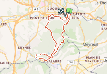

Length
17.9 km

Max alt
316 m

Uphill gradient
428 m
Km-Effort
24 km

Min alt
135 m

Downhill gradient
427 m
Boucle
Yes
Creation date :
2023-10-19 06:20:59.155
Updated on :
2023-10-19 12:45:29.955
6h23
Difficulty : Very difficult

FREE GPS app for hiking
 SityTrail
IGN / Geographical institutes
SityTrail Plus
The world is yours!
About
Trail Walking of 17.9 km to be discovered at Provence-Alpes-Côte d'Azur, Bouches-du-Rhône, Aix-en-Provence. This trail is proposed by rlebasque.
Positioning
Country:
France
Region :
Provence-Alpes-Côte d'Azur
Department/Province :
Bouches-du-Rhône
Municipality :
Aix-en-Provence
Location:
Unknown
Start:(Dec)
Start:(UTM)
699340 ; 4820337 (31T) N.
Comments