


les ailes satre goulandiere

BELLETGE
User
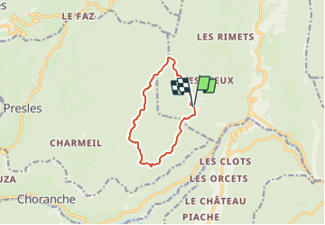

Length
9.4 km

Max alt
1373 m

Uphill gradient
408 m
Km-Effort
14.8 km

Min alt
1055 m

Downhill gradient
409 m
Boucle
Yes
Creation date :
2023-10-19 09:13:37.015
Updated on :
2023-10-19 13:09:02.183
2h22
Difficulty : Easy

FREE GPS app for hiking
 SityTrail
IGN / Geographical institutes
SityTrail Plus
The world is yours!
About
Trail Walking of 9.4 km to be discovered at Auvergne-Rhône-Alpes, Isère, Rencurel. This trail is proposed by BELLETGE.
Positioning
Country:
France
Region :
Auvergne-Rhône-Alpes
Department/Province :
Isère
Municipality :
Rencurel
Location:
Unknown
Start:(Dec)
Start:(UTM)
692640 ; 4996094 (31T) N.
Comments