


trail VSV 13 kms

fredo63
User
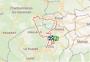

Length
12.9 km

Max alt
743 m

Uphill gradient
446 m
Km-Effort
18.8 km

Min alt
482 m

Downhill gradient
458 m
Boucle
No
Creation date :
2015-02-08 00:00:00.0
Updated on :
2015-02-08 00:00:00.0
1h39
Difficulty : Medium

FREE GPS app for hiking
 SityTrail
IGN / Geographical institutes
SityTrail Plus
The world is yours!
About
Trail Running of 12.9 km to be discovered at Auvergne-Rhône-Alpes, Puy-de-Dôme, Volvic. This trail is proposed by fredo63.
Positioning
Country:
France
Region :
Auvergne-Rhône-Alpes
Department/Province :
Puy-de-Dôme
Municipality :
Volvic
Location:
Unknown
Start:(Dec)
Start:(UTM)
503207 ; 5080144 (31T) N.
Comments
3h30 en marchant....