Trail Walking Besançon - Sous les buis - Photo

Marchez curieux

© OpenStreetMap contributors
Length
Length
6 km
Max alt
Max alt
486 m
Uphill gradient
Uphill gradient
200 m
Km-Effort
Km-Effort  
8.6 km
Min alt
Min alt
320 m
Downhill gradient
Downhill gradient
200 m
Boucle
Boucle
Yes
Creation date :
2023-10-19 14:31:31.0
Updated on :
2023-10-31 17:13:32.275

(0 Reviews)

Walking
Walking
1h58
Difficulty : Medium

Scan this QR Code to open this trail in the SityTrail application

FREE GPS app for hiking

Logo SityTrail SityTrail

IGN / Geographical institutes

Download SityTrail from the App Store Download SityTrail from Google Play

Logo SityTrail SityTrail Plus

The world is yours!

Download SityTrail from the App Store Download SityTrail from Google Play Download SityTrail on Huawei AppGallery

About

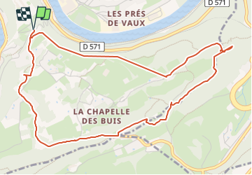
Trail Walking of 6 km to be discovered at Bourgogne-Franche-Comté, Doubs, Besançon. This trail is proposed by RSVT Rando.

Description

Attention, le passage au bord de la falaise de Vaux-Les-Prés est pas recommandée avec un public fragile. Quelques passages délicat hors sentiers balisés.

Elevation profile

Positioning

Country:
France
Region :
Bourgogne-Franche-Comté
Department/Province :
Doubs
Municipality :
Besançon
Location:
Unknown
Start:(UTM)
275643 ; 5234661 (32T) N.


Close
My subscriptions