


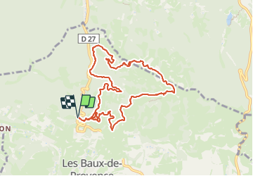
2023.10.19 - Le haut des Baux de Provence

rando30129
User

Length
10.7 km

Max alt
304 m

Uphill gradient
300 m
Km-Effort
14.7 km

Min alt
133 m

Downhill gradient
300 m
Boucle
Yes
Creation date :
2023-10-19 11:41:06.0
Updated on :
2023-11-04 09:28:24.021
3h11
Difficulty : Unknown

FREE GPS app for hiking
 SityTrail
IGN / Geographical institutes
SityTrail Plus
The world is yours!
About
Trail Trail of 10.7 km to be discovered at Provence-Alpes-Côte d'Azur, Bouches-du-Rhône, Les Baux-de-Provence. This trail is proposed by rando30129.
Positioning
Country:
France
Region :
Provence-Alpes-Côte d'Azur
Department/Province :
Bouches-du-Rhône
Municipality :
Les Baux-de-Provence
Location:
Unknown
Start:(Dec)
Start:(UTM)
644245 ; 4845986 (31T) N.
Comments