


Circuit des villages perchés en Montagne Noire labastide Esparbairenque

caccini
User
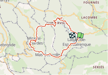

Length
18.1 km

Max alt
806 m

Uphill gradient
752 m
Km-Effort
28 km

Min alt
306 m

Downhill gradient
747 m
Boucle
Yes
Creation date :
2023-10-19 06:54:48.48
Updated on :
2023-10-20 13:09:26.772
6h23
Difficulty : Very difficult

FREE GPS app for hiking
 SityTrail
IGN / Geographical institutes
SityTrail Plus
The world is yours!
About
Trail Walking of 18.1 km to be discovered at Occitania, Aude, Labastide-Esparbairenque. This trail is proposed by caccini.
Description
randonnée
Positioning
Country:
France
Region :
Occitania
Department/Province :
Aude
Municipality :
Labastide-Esparbairenque
Location:
Unknown
Start:(Dec)
Start:(UTM)
450924 ; 4803294 (31T) N.
Comments