


villages perchés

elexine23
User
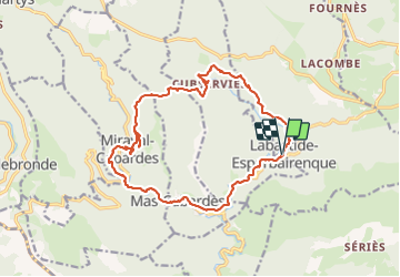

Length
19 km

Max alt
806 m

Uphill gradient
776 m
Km-Effort
29 km

Min alt
300 m

Downhill gradient
771 m
Boucle
Yes
Creation date :
2023-10-19 06:52:59.515
Updated on :
2023-10-19 15:05:55.187
5h15
Difficulty : Difficult

FREE GPS app for hiking
 SityTrail
IGN / Geographical institutes
SityTrail Plus
The world is yours!
About
Trail Walking of 19 km to be discovered at Occitania, Aude, Labastide-Esparbairenque. This trail is proposed by elexine23.
Positioning
Country:
France
Region :
Occitania
Department/Province :
Aude
Municipality :
Labastide-Esparbairenque
Location:
Unknown
Start:(Dec)
Start:(UTM)
450910 ; 4803292 (31T) N.
Comments