


Braine-l'alleud zoning bois

geoffrayLayeux
User
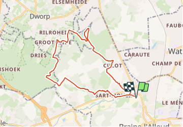

Length
16 km

Max alt
138 m

Uphill gradient
299 m
Km-Effort
20 km

Min alt
61 m

Downhill gradient
299 m
Boucle
Yes
Creation date :
2023-10-19 16:26:38.184
Updated on :
2023-10-19 16:27:33.465
0m
Difficulty : Very easy

FREE GPS app for hiking
 SityTrail
IGN / Geographical institutes
SityTrail Plus
The world is yours!
About
Trail Nordic walking of 16 km to be discovered at Wallonia, Walloon Brabant, Braine-l’Alleud. This trail is proposed by geoffrayLayeux.
Positioning
Country:
Belgium
Region :
Wallonia
Department/Province :
Walloon Brabant
Municipality :
Braine-l’Alleud
Location:
Braine-l’Alleud
Start:(Dec)
Start:(UTM)
596327 ; 5616828 (31U) N.
Comments