


GR34 - 30

loic09
User
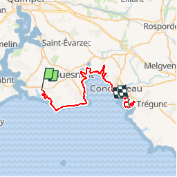

Length
42 km

Max alt
27 m

Uphill gradient
329 m
Km-Effort
47 km

Min alt
-3 m

Downhill gradient
339 m
Boucle
No
Creation date :
2015-03-16 00:00:00.0
Updated on :
2015-03-16 00:00:00.0
6h00
Difficulty : Medium

FREE GPS app for hiking
 SityTrail
IGN / Geographical institutes
SityTrail Plus
The world is yours!
About
Trail Running of 42 km to be discovered at Brittany, Finistère, Bénodet. This trail is proposed by loic09.
Description
Pont Henvez/Pointe de Grignallou
Positioning
Country:
France
Region :
Brittany
Department/Province :
Finistère
Municipality :
Bénodet
Location:
Unknown
Start:(Dec)
Start:(UTM)
420008 ; 5302663 (30T) N.
Comments
