


champagne 2023

goizet
User
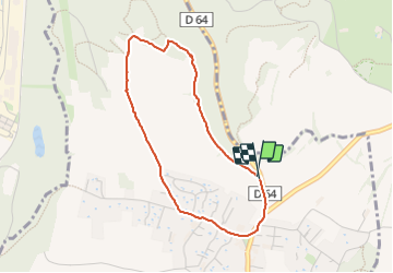

Length
3.5 km

Max alt
394 m

Uphill gradient
56 m
Km-Effort
4.3 km

Min alt
360 m

Downhill gradient
61 m
Boucle
Yes
Creation date :
2023-10-21 13:41:39.461
Updated on :
2023-10-21 14:43:39.719
1h01
Difficulty : Very easy

FREE GPS app for hiking
 SityTrail
IGN / Geographical institutes
SityTrail Plus
The world is yours!
About
Trail Walking of 3.5 km to be discovered at Auvergne-Rhône-Alpes, Isère, Champagnier. This trail is proposed by goizet.
Positioning
Country:
France
Region :
Auvergne-Rhône-Alpes
Department/Province :
Isère
Municipality :
Champagnier
Location:
Unknown
Start:(Dec)
Start:(UTM)
714705 ; 4999578 (31T) N.
Comments