


Le Mont-Serein Tête de la Grave 14km.

chancha
User GUIDE
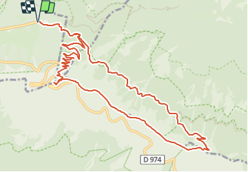

Length
14 km

Max alt
1907 m

Uphill gradient
653 m
Km-Effort
23 km

Min alt
1400 m

Downhill gradient
653 m
Boucle
Yes
Creation date :
2023-10-22 08:05:54.945
Updated on :
2023-10-23 18:50:10.5
5h10
Difficulty : Very difficult

FREE GPS app for hiking
 SityTrail
IGN / Geographical institutes
SityTrail Plus
The world is yours!
About
Trail Walking of 14 km to be discovered at Provence-Alpes-Côte d'Azur, Vaucluse, Beaumont-du-Ventoux. This trail is proposed by chancha.
Positioning
Country:
France
Region :
Provence-Alpes-Côte d'Azur
Department/Province :
Vaucluse
Municipality :
Beaumont-du-Ventoux
Location:
Unknown
Start:(Dec)
Start:(UTM)
681776 ; 4894933 (31T) N.
Comments