


les orchidées

VANDERPUTTENMi
User GUIDE
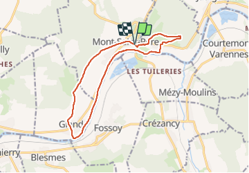

Length
13.6 km

Max alt
186 m

Uphill gradient
262 m
Km-Effort
17.1 km

Min alt
56 m

Downhill gradient
261 m
Boucle
Yes
Creation date :
2023-10-19 07:43:44.013
Updated on :
2023-10-23 16:44:52.556
3h18
Difficulty : Difficult

FREE GPS app for hiking
 SityTrail
IGN / Geographical institutes
SityTrail Plus
The world is yours!
About
Trail Walking of 13.6 km to be discovered at Hauts-de-France, Aisne, Mont-Saint-Père. This trail is proposed by VANDERPUTTENMi.
Positioning
Country:
France
Region :
Hauts-de-France
Department/Province :
Aisne
Municipality :
Mont-Saint-Père
Location:
Unknown
Start:(Dec)
Start:(UTM)
536139 ; 5435882 (31U) N.
Comments