


La Montagne de Saint-Génis (05)

Clo0413
User
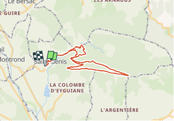

Length
17.8 km

Max alt
1240 m

Uphill gradient
725 m
Km-Effort
28 km

Min alt
705 m

Downhill gradient
729 m
Boucle
Yes
Creation date :
2023-10-23 07:25:36.791
Updated on :
2023-10-23 20:52:50.404
6h15
Difficulty : Very difficult

FREE GPS app for hiking
 SityTrail
IGN / Geographical institutes
SityTrail Plus
The world is yours!
About
Trail Walking of 17.8 km to be discovered at Provence-Alpes-Côte d'Azur, Hautes-Alpes, Garde-Colombe. This trail is proposed by Clo0413.
Positioning
Country:
France
Region :
Provence-Alpes-Côte d'Azur
Department/Province :
Hautes-Alpes
Municipality :
Garde-Colombe
Location:
Unknown
Start:(Dec)
Start:(UTM)
720444 ; 4917626 (31T) N.
Comments