


depart parking du collet vers plan des cavalles

gerardmicheline
User
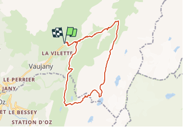

Length
16.6 km

Max alt
2648 m

Uphill gradient
1329 m
Km-Effort
34 km

Min alt
1367 m

Downhill gradient
1332 m
Boucle
Yes
Creation date :
2023-10-24 08:32:32.052
Updated on :
2023-10-24 08:38:03.322
7h48
Difficulty : Very difficult

FREE GPS app for hiking
 SityTrail
IGN / Geographical institutes
SityTrail Plus
The world is yours!
About
Trail Walking of 16.6 km to be discovered at Auvergne-Rhône-Alpes, Isère, Vaujany. This trail is proposed by gerardmicheline.
Positioning
Country:
France
Region :
Auvergne-Rhône-Alpes
Department/Province :
Isère
Municipality :
Vaujany
Location:
Unknown
Start:(Dec)
Start:(UTM)
271681 ; 5005762 (32T) N.
Comments