


chemin de l'arnette

Mascart
User
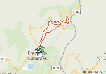

Length
7.5 km

Max alt
1211 m

Uphill gradient
389 m
Km-Effort
12.7 km

Min alt
810 m

Downhill gradient
397 m
Boucle
No
Creation date :
2023-10-24 11:52:17.998
Updated on :
2023-10-24 16:57:35.226
4h06
Difficulty : Medium

FREE GPS app for hiking
 SityTrail
IGN / Geographical institutes
SityTrail Plus
The world is yours!
About
Trail Walking of 7.5 km to be discovered at Occitania, Aude, Pradelles-Cabardès. This trail is proposed by Mascart.
Description
pic de Nore
Positioning
Country:
France
Region :
Occitania
Department/Province :
Aude
Municipality :
Pradelles-Cabardès
Location:
Unknown
Start:(Dec)
Start:(UTM)
455131 ; 4806225 (31T) N.
Comments