


ST MYON

Papou63patrick
User
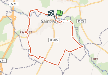

Length
9.2 km

Max alt
431 m

Uphill gradient
127 m
Km-Effort
10.9 km

Min alt
336 m

Downhill gradient
126 m
Boucle
Yes
Creation date :
2023-10-25 12:02:33.776
Updated on :
2023-10-25 14:55:03.443
2h51
Difficulty : Easy

FREE GPS app for hiking
 SityTrail
IGN / Geographical institutes
SityTrail Plus
The world is yours!
About
Trail Walking of 9.2 km to be discovered at Auvergne-Rhône-Alpes, Puy-de-Dôme, Saint-Myon. This trail is proposed by Papou63patrick.
Positioning
Country:
France
Region :
Auvergne-Rhône-Alpes
Department/Province :
Puy-de-Dôme
Municipality :
Saint-Myon
Location:
Unknown
Start:(Dec)
Start:(UTM)
510358 ; 5093485 (31T) N.
Comments