


2610

maxEA65
User
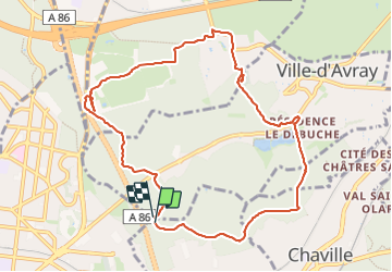

Length
9.8 km

Max alt
188 m

Uphill gradient
181 m
Km-Effort
12.2 km

Min alt
121 m

Downhill gradient
182 m
Boucle
Yes
Creation date :
2023-10-26 06:34:41.972
Updated on :
2023-10-26 08:40:02.503
2h04
Difficulty : Difficult

FREE GPS app for hiking
 SityTrail
IGN / Geographical institutes
SityTrail Plus
The world is yours!
About
Trail Walking of 9.8 km to be discovered at Ile-de-France, Yvelines, Viroflay. This trail is proposed by maxEA65.
Positioning
Country:
France
Region :
Ile-de-France
Department/Province :
Yvelines
Municipality :
Viroflay
Location:
Unknown
Start:(Dec)
Start:(UTM)
438489 ; 5406898 (31U) N.
Comments