


depart du gite vers allemond

gerardmicheline
User
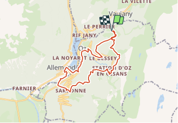

Length
15.7 km

Max alt
1497 m

Uphill gradient
1055 m
Km-Effort
30 km

Min alt
725 m

Downhill gradient
1061 m
Boucle
Yes
Creation date :
2023-10-26 14:16:17.986
Updated on :
2023-10-26 14:17:05.236
6h46
Difficulty : Very difficult

FREE GPS app for hiking
 SityTrail
IGN / Geographical institutes
SityTrail Plus
The world is yours!
About
Trail Walking of 15.7 km to be discovered at Auvergne-Rhône-Alpes, Isère, Oz. This trail is proposed by gerardmicheline.
Positioning
Country:
France
Region :
Auvergne-Rhône-Alpes
Department/Province :
Isère
Municipality :
Oz
Location:
Unknown
Start:(Dec)
Start:(UTM)
269864 ; 5003674 (32T) N.
Comments