


13 - Source de l Infernet et la Cadiere

chris13370
User

Length
47 km

Max alt
315 m

Uphill gradient
1163 m
Km-Effort
63 km

Min alt
50 m

Downhill gradient
1121 m
Boucle
No
Creation date :
2023-10-26 07:33:56.099
Updated on :
2023-10-26 14:37:06.476
4h00
Difficulty : Easy

FREE GPS app for hiking
 SityTrail
IGN / Geographical institutes
SityTrail Plus
The world is yours!
About
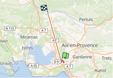
Trail Walking of 47 km to be discovered at Provence-Alpes-Côte d'Azur, Bouches-du-Rhône, Vitrolles. This trail is proposed by chris13370.
Description
Entre Vitrolles et les Pennes Mirabeau
Positioning
Country:
France
Region :
Provence-Alpes-Côte d'Azur
Department/Province :
Bouches-du-Rhône
Municipality :
Vitrolles
Location:
Unknown
Start:(Dec)
Start:(UTM)
685339 ; 4810031 (31T) N.
Comments