


rando chatou

Franpey
User
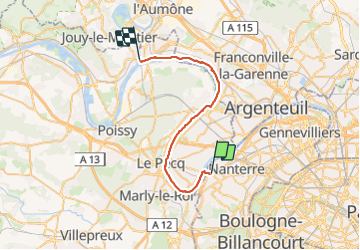

Length
32 km

Max alt
71 m

Uphill gradient
363 m
Km-Effort
37 km

Min alt
14 m

Downhill gradient
366 m
Boucle
No
Creation date :
2023-10-26 06:42:09.453
Updated on :
2023-10-26 20:41:45.663
8h22
Difficulty : Very difficult

FREE GPS app for hiking
 SityTrail
IGN / Geographical institutes
SityTrail Plus
The world is yours!
About
Trail Walking of 32 km to be discovered at Ile-de-France, Hauts-de-Seine, Rueil-Malmaison. This trail is proposed by Franpey.
Positioning
Country:
France
Region :
Ile-de-France
Department/Province :
Hauts-de-Seine
Municipality :
Rueil-Malmaison
Location:
Unknown
Start:(Dec)
Start:(UTM)
439346 ; 5415294 (31U) N.
Comments