


Lizine Alaise

RSVT Rando
Marchez curieux

Length
16.7 km

Max alt
492 m

Uphill gradient
499 m
Km-Effort
23 km

Min alt
322 m

Downhill gradient
498 m
Boucle
Yes
Creation date :
2023-10-26 15:31:24.0
Updated on :
2023-10-31 17:03:37.781
5h17
Difficulty : Very difficult

FREE GPS app for hiking
 SityTrail
IGN / Geographical institutes
SityTrail Plus
The world is yours!
About
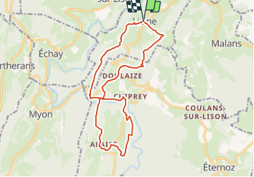
Trail Walking of 16.7 km to be discovered at Bourgogne-Franche-Comté, Doubs, Lizine. This trail is proposed by RSVT Rando.
Description
L'occasion d'évoquer l'hypothèse d'Alésia sur ce plateau d'Alaise.
Positioning
Country:
France
Region :
Bourgogne-Franche-Comté
Department/Province :
Doubs
Municipality :
Lizine
Location:
Unknown
Start:(Dec)
Start:(UTM)
727292 ; 5215751 (31T) N.
Comments