


Variante j2

ophness
User
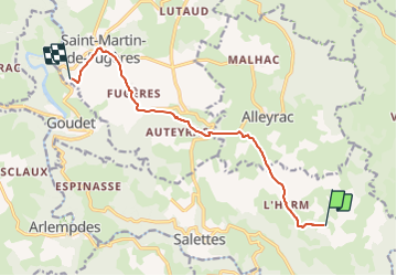

Length
10 km

Max alt
1125 m

Uphill gradient
186 m
Km-Effort
13 km

Min alt
933 m

Downhill gradient
328 m
Boucle
No
Creation date :
2023-10-27 13:31:45.0
Updated on :
2023-10-27 13:31:46.456

FREE GPS app for hiking
 SityTrail
IGN / Geographical institutes
SityTrail Plus
The world is yours!
About
Trail of 10 km to be discovered at Auvergne-Rhône-Alpes, Haute-Loire, Salettes. This trail is proposed by ophness.
Positioning
Country:
France
Region :
Auvergne-Rhône-Alpes
Department/Province :
Haute-Loire
Municipality :
Salettes
Location:
Unknown
Start:(Dec)
Start:(UTM)
579337 ; 4968528 (31T) N.
Comments