


Bouc-Bel-Air San Baquis

MAUVAGE Patrick
User
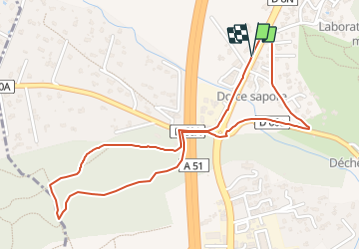

Length
2.7 km

Max alt
205 m

Uphill gradient
46 m
Km-Effort
3.3 km

Min alt
165 m

Downhill gradient
48 m
Boucle
Yes
Creation date :
2023-10-28 09:00:02.0
Updated on :
2023-10-29 09:25:16.871
45m
Difficulty : Easy

FREE GPS app for hiking
 SityTrail
IGN / Geographical institutes
SityTrail Plus
The world is yours!
About
Trail Walking of 2.7 km to be discovered at Provence-Alpes-Côte d'Azur, Bouches-du-Rhône, Bouc-Bel-Air. This trail is proposed by MAUVAGE Patrick.
Positioning
Country:
France
Region :
Provence-Alpes-Côte d'Azur
Department/Province :
Bouches-du-Rhône
Municipality :
Bouc-Bel-Air
Location:
Unknown
Start:(Dec)
Start:(UTM)
694069 ; 4813557 (31T) N.
Comments