


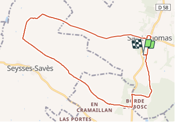
St Thomas fait 2023

pidjam
User

Length
11.2 km

Max alt
326 m

Uphill gradient
214 m
Km-Effort
14.1 km

Min alt
182 m

Downhill gradient
214 m
Boucle
Yes
Creation date :
2023-10-29 07:36:01.284
Updated on :
2023-10-29 15:46:06.759
3h11
Difficulty : Difficult

FREE GPS app for hiking
 SityTrail
IGN / Geographical institutes
SityTrail Plus
The world is yours!
About
Trail Walking of 11.2 km to be discovered at Occitania, Haute-Garonne, Saint-Thomas. This trail is proposed by pidjam.
Positioning
Country:
France
Region :
Occitania
Department/Province :
Haute-Garonne
Municipality :
Saint-Thomas
Location:
Unknown
Start:(Dec)
Start:(UTM)
344838 ; 4819242 (31T) N.
Comments