


erttyy

Clo0413
User
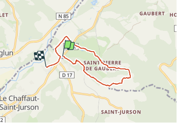

Length
6.6 km

Max alt
675 m

Uphill gradient
144 m
Km-Effort
8.6 km

Min alt
522 m

Downhill gradient
164 m
Boucle
No
Creation date :
2023-10-29 13:49:27.923
Updated on :
2023-10-29 16:14:06.95
1h57
Difficulty : Easy

FREE GPS app for hiking
 SityTrail
IGN / Geographical institutes
SityTrail Plus
The world is yours!
About
Trail Walking of 6.6 km to be discovered at Provence-Alpes-Côte d'Azur, Alpes-de-Haute-Provence, Digne-les-Bains. This trail is proposed by Clo0413.
Positioning
Country:
France
Region :
Provence-Alpes-Côte d'Azur
Department/Province :
Alpes-de-Haute-Provence
Municipality :
Digne-les-Bains
Location:
Unknown
Start:(Dec)
Start:(UTM)
272905 ; 4881333 (32T) N.
Comments