


Le poil valbonnette

Danielba
User GUIDE
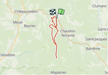

Length
24 km

Max alt
1354 m

Uphill gradient
1040 m
Km-Effort
38 km

Min alt
636 m

Downhill gradient
1037 m
Boucle
Yes
Creation date :
2023-10-29 06:45:40.313
Updated on :
2023-10-29 17:39:21.673
8h56
Difficulty : Medium

FREE GPS app for hiking
 SityTrail
IGN / Geographical institutes
SityTrail Plus
The world is yours!
About
Trail Walking of 24 km to be discovered at Provence-Alpes-Côte d'Azur, Alpes-de-Haute-Provence, Chaudon-Norante. This trail is proposed by Danielba .
Photos


Positioning
Country:
France
Region :
Provence-Alpes-Côte d'Azur
Department/Province :
Alpes-de-Haute-Provence
Municipality :
Chaudon-Norante
Location:
Unknown
Start:(Dec)
Start:(UTM)
282397 ; 4875755 (32T) N.
Comments