Trail Walking Narbonne - La combe d'enfer en Narbonnais  - Photo

La combe d'enfer en Narbonnais

© OpenStreetMap contributors
Length
Length
15.9 km
Max alt
Max alt
271 m
Uphill gradient
Uphill gradient
352 m
Km-Effort
Km-Effort  
21 km
Min alt
Min alt
98 m
Downhill gradient
Downhill gradient
352 m
Boucle
Boucle
Yes
Creation date :
2023-10-22 07:32:30.533
Updated on :
2023-10-30 16:12:57.696

(0 Reviews)

Walking
Walking
4h30
Difficulty : Easy
Mountain bike
Mountain bike
2h30
Difficulty : Medium

Scan this QR Code to open this trail in the SityTrail application

FREE GPS app for hiking

Logo SityTrail SityTrail

IGN / Geographical institutes

Download SityTrail from the App Store Download SityTrail from Google Play

Logo SityTrail SityTrail Plus

The world is yours!

Download SityTrail from the App Store Download SityTrail from Google Play Download SityTrail on Huawei AppGallery

About

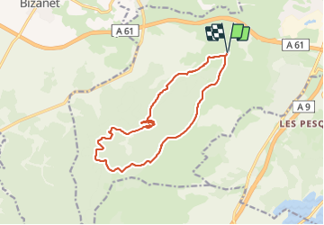
Trail Walking of 15.9 km to be discovered at Occitania, Aude, Narbonne. This trail is proposed by Raymond DAVID .

Description

Randonnée sans difficulté si on évite le passage dans la combe d'Enfer. Visite de l'abbaye de Fontfroide payante.
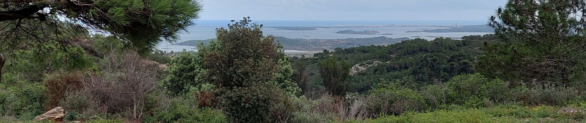
A faire dans le sens anti-horaire, des vues sur l'arrière pays le matin et vers la mer et les étangs l'après-midi.
A éviter par fortes chaleurs

Elevation profile

Photos

Positioning

Country:
France
Region :
Occitania
Department/Province :
Aude
Municipality :
Narbonne
Location:
Unknown
Start:(UTM)
495401 ; 4777543 (31T) N.


Close
My subscriptions