![](/images/other/stat-length.png)
![Trail Walking Gavarnie-Gèdre - Plateau de Bellevue. Cirque de Gavarnie - Photo](https://media.geolcdn.com/t/1900/400/ext.pjpeg?maxdim=2&url=https%3A%2F%2Fstatic1.geolcdn.com%2Fsiteimages%2Fupload%2Ffiles%2F1553511878bg_sport_marche.png)
Plateau de Bellevue. Cirque de Gavarnie
JMFr
User
![Length](/images/other/stat-length.png)
Length
14.3 km
![Max alt](https://static1.geolcdn.com/siteimages/upload/files/1508320355ic_sort_altitude_max_24dp.png)
Max alt
1871 m
![Uphill gradient](https://static1.geolcdn.com/siteimages/upload/files/1508320355ic_sort_den_pos_24dp.png)
Uphill gradient
706 m
![Km-Effort](/images/other/stat-length.png)
Km-Effort
24 km
![Min alt](https://static1.geolcdn.com/siteimages/upload/files/1508320355ic_sort_altitude_min_24dp.png)
Min alt
1367 m
![Downhill gradient](https://static1.geolcdn.com/siteimages/upload/files/1508320355ic_sort_den_neg_24dp.png)
Downhill gradient
710 m
![Boucle](https://static1.geolcdn.com/siteimages/upload/files/16400158638029165_repeat_loop_refresh_sync_direction_icon.png)
Boucle
Yes
Creation date :
2023-10-31 09:58:14.835
Updated on :
2023-11-01 08:34:04.791
![Walking](https://static1.geolcdn.com/sitytour/trail-icons/101.png)
3h26
Difficulty : Medium
![Scan this QR Code to open this trail in the SityTrail application](https://capi.geolives.com/qq0zvz2zws4bq2lad0pu/sitytour/trails/3855619/qr.png?size=200)
FREE GPS app for hiking
About
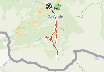
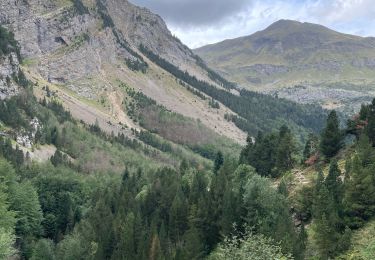
Trail Walking of 14.3 km to be discovered at Occitania, Hautespyrenees, Gavarnie-Gèdre. This trail is proposed by JMFr.
Description
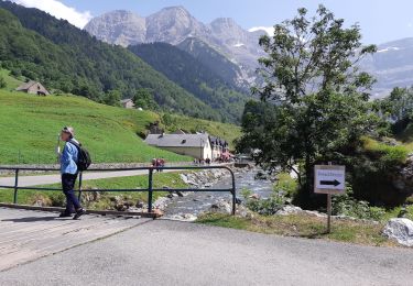
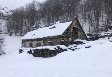
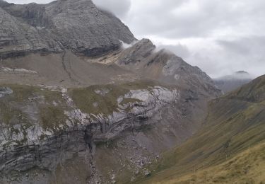
Belle randonnée d'automne en dehors du chemin classique. Le passage par le plateau de Bellevue permet d'avoir un magnifique et exceptionnel panorama sur le cirque, la cascade et les 3000 environnants...
Positioning
Country:
France
Region :
Occitania
Department/Province :
Hautespyrenees
Municipality :
Gavarnie-Gèdre
Location:
Gavarnie
Start:(Dec)
Start:(UTM)
744658 ; 4735760 (30T) N.
Comments
Trails nearby
![Trail Walking Gavarnie-Gèdre - Breche de Rolland - Photo](https://media.geolcdn.com/t/375/260/ext.jpg?maxdim=2&url=https%3A%2F%2Fservices.sitytrail.com%2FGeolivesWS%2FDownloadMedia.ashx%3FTrailID%3D334692%26Media%3Dfix__20140811120248.jpg)
![Walking Walking](https://static1.geolcdn.com/sitytour/trail-icons/101.png)
Breche de Rolland
Walking
Easy
(3)
Gavarnie-Gèdre,
Occitania,
Hautespyrenees,
France
![](/images/other/stat-length.png)
12.1 km | 22 km-effort
4h 34min
![](https://static1.geolcdn.com/siteimages/upload/files/16400158638029165_repeat_loop_refresh_sync_direction_icon.png)
Yes
![Trail Walking Gavarnie-Gèdre - Le Cirque de Gavarnie autrement - Photo](https://media.geolcdn.com/t/375/260/ext.jpg?maxdim=2&url=https%3A%2F%2Fservices.sitytrail.com%2FGeolivesWS%2FDownloadMedia.ashx%3FTrailID%3D103374%26Media%3D5436_6.jpg)
![Walking Walking](https://static1.geolcdn.com/sitytour/trail-icons/101.png)
Le Cirque de Gavarnie autrement
Walking
Medium
(2)
Gavarnie-Gèdre,
Occitania,
Hautespyrenees,
France
![](/images/other/stat-length.png)
9.1 km | 15.6 km-effort
3h 0min
![](https://static1.geolcdn.com/siteimages/upload/files/16400158638029165_repeat_loop_refresh_sync_direction_icon.png)
Yes
![Trail Walking Gavarnie-Gèdre - Faja de las Flores - Photo](https://media.geolcdn.com/t/375/260/ext.jpg?maxdim=2&url=https%3A%2F%2Fservices.sitytrail.com%2FGeolivesWS%2FDownloadMedia.ashx%3FTrailID%3D102724%26Media%3D3837_6.jpg)
![Walking Walking](https://static1.geolcdn.com/sitytour/trail-icons/101.png)
Faja de las Flores
Walking
Very difficult
(1)
Gavarnie-Gèdre,
Occitania,
Hautespyrenees,
France
![](/images/other/stat-length.png)
22 km | 45 km-effort
13h 0min
![](https://static1.geolcdn.com/siteimages/upload/files/16400158638029165_repeat_loop_refresh_sync_direction_icon.png)
Yes
![Trail Walking Gavarnie-Gèdre - Le Soum Blanc des Especières 2685m depuis le col de Tentes - Photo](https://media.geolcdn.com/t/375/260/ext.jpg?maxdim=2&url=https%3A%2F%2Fservices.sitytrail.com%2FGeolivesWS%2FDownloadMedia.ashx%3FTrailID%3D109867%26Media%3D4854_1.jpg)
![Walking Walking](https://static1.geolcdn.com/sitytour/trail-icons/101.png)
Le Soum Blanc des Especières 2685m depuis le col de Tentes
Walking
Difficult
(2)
Gavarnie-Gèdre,
Occitania,
Hautespyrenees,
France
![](/images/other/stat-length.png)
5.6 km | 12.6 km-effort
3h 0min
![](https://static1.geolcdn.com/siteimages/upload/files/16400158638029165_repeat_loop_refresh_sync_direction_icon.png)
Yes
![Trail Walking Gavarnie-Gèdre - Le Casque du Marboré 3006m depuis le col de Tentes (2208m) - Photo](https://media.geolcdn.com/t/375/260/ext.jpg?maxdim=2&url=https%3A%2F%2Fservices.sitytrail.com%2FGeolivesWS%2FDownloadMedia.ashx%3FTrailID%3D109814%26Media%3D4776_1.jpg)
![Walking Walking](https://static1.geolcdn.com/sitytour/trail-icons/101.png)
Le Casque du Marboré 3006m depuis le col de Tentes (2208m)
Walking
Very difficult
(1)
Gavarnie-Gèdre,
Occitania,
Hautespyrenees,
France
![](/images/other/stat-length.png)
7 km | 16.4 km-effort
7h 0min
![](https://static1.geolcdn.com/siteimages/upload/files/16400158638029165_repeat_loop_refresh_sync_direction_icon.png)
No
![Trail Walking Gavarnie-Gèdre - GAVARNIE avec Pierre D, Christine et Michel Blavit 3740150 - Photo](https://media.geolcdn.com/t/375/260/ext.jpg?maxdim=2&url=https%3A%2F%2Fmedia.geolcdn.com%2Ff%2Fdd58b21f-efc7-4d10-b038-8a72ccb92536.jpg)
![Walking Walking](https://static1.geolcdn.com/sitytour/trail-icons/101.png)
GAVARNIE avec Pierre D, Christine et Michel Blavit 3740150
Walking
Difficult
Gavarnie-Gèdre,
Occitania,
Hautespyrenees,
France
![](/images/other/stat-length.png)
10.5 km | 17.2 km-effort
3h 53min
![](https://static1.geolcdn.com/siteimages/upload/files/16400158638029165_repeat_loop_refresh_sync_direction_icon.png)
Yes
![Trail Horseback riding Gavarnie-Gèdre - Cirque de Gavarnie et variante - Photo](https://media.geolcdn.com/t/375/260/ext.jpg?maxdim=2&url=https%3A%2F%2Fmedia.geolcdn.com%2Ff%2F85d1392a-7f00-4f3f-8519-147898e5e510.jpg)
![Horseback riding Horseback riding](https://static1.geolcdn.com/sitytour/trail-icons/301.png)
Cirque de Gavarnie et variante
Horseback riding
Easy
Gavarnie-Gèdre,
Occitania,
Hautespyrenees,
France
![](/images/other/stat-length.png)
29 km | 37 km-effort
3h 12min
![](https://static1.geolcdn.com/siteimages/upload/files/16400158638029165_repeat_loop_refresh_sync_direction_icon.png)
No
![Trail Walking Gavarnie-Gèdre - 65-Brèche-de-Roland(AR)-12Km/700m - Photo](https://media.geolcdn.com/t/375/260/ext.jpg?maxdim=2&url=https%3A%2F%2Fmedia.geolcdn.com%2Ff%2F51dd1e54-8b9b-42e9-a29f-6a2a0a557f03.jpg)
![Walking Walking](https://static1.geolcdn.com/sitytour/trail-icons/101.png)
65-Brèche-de-Roland(AR)-12Km/700m
Walking
Difficult
Gavarnie-Gèdre,
Occitania,
Hautespyrenees,
France
![](/images/other/stat-length.png)
11.6 km | 21 km-effort
4h 46min
![](https://static1.geolcdn.com/siteimages/upload/files/16400158638029165_repeat_loop_refresh_sync_direction_icon.png)
Yes
![Trail Walking Gavarnie-Gèdre - Le cirque de gavarnie - Photo](https://media.geolcdn.com/t/375/260/ext.jpg?maxdim=2&url=https%3A%2F%2Fmedia.geolcdn.com%2Ff%2F9a8dc54d-29d3-4c1b-b155-5e6677c2d23c.jpg)
![Walking Walking](https://static1.geolcdn.com/sitytour/trail-icons/101.png)
Le cirque de gavarnie
Walking
Difficult
Gavarnie-Gèdre,
Occitania,
Hautespyrenees,
France
![](/images/other/stat-length.png)
10.3 km | 16.3 km-effort
3h 21min
![](https://static1.geolcdn.com/siteimages/upload/files/16400158638029165_repeat_loop_refresh_sync_direction_icon.png)
No