


chapelle Saint Michel

vindju
User
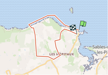

Length
6.9 km

Max alt
65 m

Uphill gradient
90 m
Km-Effort
8 km

Min alt
0 m

Downhill gradient
72 m
Boucle
Yes
Creation date :
2023-11-01 11:29:50.807
Updated on :
2023-11-01 11:30:52.142
1h49
Difficulty : Medium

FREE GPS app for hiking
 SityTrail
IGN / Geographical institutes
SityTrail Plus
The world is yours!
About
Trail Walking of 6.9 km to be discovered at France. This trail is proposed by vindju.
Positioning
Country:
France
Region :
Unknown
Department/Province :
Unknown
Municipality :
Unknown
Location:
Unknown
Start:(Dec)
Start:(UTM)
542633 ; 5388450 (30U) N.
Comments