


2023-11-03_14h12m05_B28 La Sauvie - Vallée de la Vis

34christophe
User
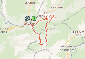

Length
16.9 km

Max alt
694 m

Uphill gradient
618 m
Km-Effort
25 km

Min alt
220 m

Downhill gradient
618 m
Boucle
Yes
Creation date :
2023-11-03 13:12:06.537
Updated on :
2024-04-01 16:49:48.489
5h43
Difficulty : Difficult

FREE GPS app for hiking
 SityTrail
IGN / Geographical institutes
SityTrail Plus
The world is yours!
About
Trail Walking of 16.9 km to be discovered at Occitania, Gard, Rogues. This trail is proposed by 34christophe.
Description
variante en 17km
Positioning
Country:
France
Region :
Occitania
Department/Province :
Gard
Municipality :
Rogues
Location:
Unknown
Start:(Dec)
Start:(UTM)
545419 ; 4855862 (31T) N.
Comments
Madieres magnifique village 1 er moitié de retour, etroite et passage très étroit en bord de falaise. Soyez prudents.