


Étoile pennes v2

ophness
User
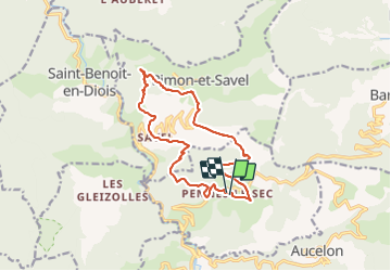

Length
15.1 km

Max alt
1003 m

Uphill gradient
701 m
Km-Effort
24 km

Min alt
522 m

Downhill gradient
693 m
Boucle
Yes
Creation date :
2023-11-03 13:27:22.0
Updated on :
2023-11-03 13:27:23.838

FREE GPS app for hiking
 SityTrail
IGN / Geographical institutes
SityTrail Plus
The world is yours!
About
Trail of 15.1 km to be discovered at Auvergne-Rhône-Alpes, Drôme, Pennes-le-Sec. This trail is proposed by ophness.
Positioning
Country:
France
Region :
Auvergne-Rhône-Alpes
Department/Province :
Drôme
Municipality :
Pennes-le-Sec
Location:
Unknown
Start:(Dec)
Start:(UTM)
683816 ; 4945285 (31T) N.
Comments