


seraing

binard
User
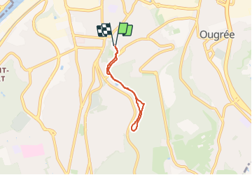

Length
4.1 km

Max alt
186 m

Uphill gradient
84 m
Km-Effort
5.3 km

Min alt
98 m

Downhill gradient
85 m
Boucle
Yes
Creation date :
2023-11-04 10:04:29.283
Updated on :
2023-11-04 11:56:05.464
1h06
Difficulty : Easy

FREE GPS app for hiking
 SityTrail
IGN / Geographical institutes
SityTrail Plus
The world is yours!
About
Trail Walking of 4.1 km to be discovered at Wallonia, Liège, Seraing. This trail is proposed by binard.
Positioning
Country:
Belgium
Region :
Wallonia
Department/Province :
Liège
Municipality :
Seraing
Location:
Unknown
Start:(Dec)
Start:(UTM)
677931 ; 5608081 (31U) N.
Comments