


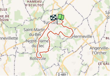
Turretot

RoMo
User

Length
13.1 km

Max alt
109 m

Uphill gradient
181 m
Km-Effort
15.5 km

Min alt
37 m

Downhill gradient
178 m
Boucle
Yes
Creation date :
2023-11-05 07:58:20.772
Updated on :
2023-11-05 11:25:43.275
3h04
Difficulty : Medium

FREE GPS app for hiking
 SityTrail
IGN / Geographical institutes
SityTrail Plus
The world is yours!
About
Trail Walking of 13.1 km to be discovered at Normandy, Seine-Maritime, Turretot. This trail is proposed by RoMo.
Description
belle boucle
Positioning
Country:
France
Region :
Normandy
Department/Province :
Seine-Maritime
Municipality :
Turretot
Location:
Unknown
Start:(Dec)
Start:(UTM)
300174 ; 5498686 (31U) N.
Comments