


la maltière - apigné

Pascal Gueno
User
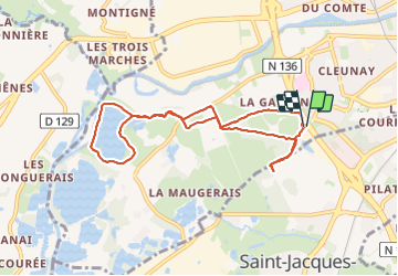

Length
8.2 km

Max alt
40 m

Uphill gradient
73 m
Km-Effort
9.2 km

Min alt
17 m

Downhill gradient
72 m
Boucle
Yes
Creation date :
2023-11-05 13:15:03.9
Updated on :
2023-11-05 14:57:27.251
1h34
Difficulty : Very easy

FREE GPS app for hiking
 SityTrail
IGN / Geographical institutes
SityTrail Plus
The world is yours!
About
Trail Walking of 8.2 km to be discovered at Brittany, Ille-et-Vilaine, Rennes. This trail is proposed by Pascal Gueno.
Positioning
Country:
France
Region :
Brittany
Department/Province :
Ille-et-Vilaine
Municipality :
Rennes
Location:
Quartiers Ouest
Start:(Dec)
Start:(UTM)
595881 ; 5327755 (30U) N.
Comments