


Col de Linas

Dominique Picot
User
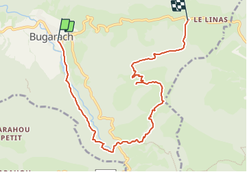

Length
8.9 km

Max alt
1210 m

Uphill gradient
797 m
Km-Effort
18.8 km

Min alt
470 m

Downhill gradient
595 m
Boucle
No
Creation date :
2023-11-06 14:03:05.539
Updated on :
2023-11-06 14:03:20.759

FREE GPS app for hiking
 SityTrail
IGN / Geographical institutes
SityTrail Plus
The world is yours!
About
Trail of 8.9 km to be discovered at Occitania, Aude, Bugarach. This trail is proposed by Dominique Picot.
Points of interest


Positioning
Country:
France
Region :
Occitania
Department/Province :
Aude
Municipality :
Bugarach
Location:
Unknown
Start:(Dec)
Start:(UTM)
447124 ; 4747118 (31T) N.
Comments