


gespunsart3.2023.11.07

trusgnachjf
User

Length
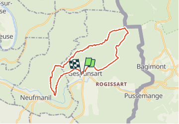
14.9 km

Max alt
367 m

Uphill gradient
391 m
Km-Effort
20 km

Min alt
197 m

Downhill gradient
394 m
Boucle
Yes
Creation date :
2023-11-07 12:45:56.353
Updated on :
2023-11-07 16:20:43.022
3h33
Difficulty : Very difficult

FREE GPS app for hiking
 SityTrail
IGN / Geographical institutes
SityTrail Plus
The world is yours!
About
Trail Walking of 14.9 km to be discovered at Grand Est, Ardennes, Gespunsart. This trail is proposed by trusgnachjf.
Description
,
Positioning
Country:
France
Region :
Grand Est
Department/Province :
Ardennes
Municipality :
Gespunsart
Location:
Unknown
Start:(Dec)
Start:(UTM)
631491 ; 5520324 (31U) N.
Comments