


2023-11-07_17h49m22_J 7

LUTZMarc
User
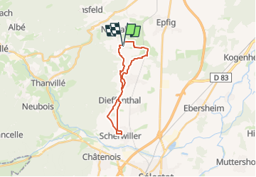

Length
18.7 km

Max alt
262 m

Uphill gradient
235 m
Km-Effort
22 km

Min alt
180 m

Downhill gradient
231 m
Boucle
Yes
Creation date :
2023-11-07 16:49:22.271
Updated on :
2024-11-01 09:10:20.755
4h57
Difficulty : Easy

FREE GPS app for hiking
 SityTrail
IGN / Geographical institutes
SityTrail Plus
The world is yours!
About
Trail Walking of 18.7 km to be discovered at Grand Est, Bas-Rhin, Blienschwiller. This trail is proposed by LUTZMarc.
Description
Facile
Resto possible à Scherwiller La Couronne
Positioning
Country:
France
Region :
Grand Est
Department/Province :
Bas-Rhin
Municipality :
Blienschwiller
Location:
Unknown
Start:(Dec)
Start:(UTM)
383103 ; 5355734 (32U) N.
Comments