Champeyroux

Papou63patrick
User
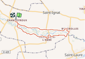

Length
7.9 km

Max alt
317 m

Uphill gradient
60 m
Km-Effort
8.7 km

Min alt
297 m

Downhill gradient
60 m
Boucle
Yes
Creation date :
2023-11-08 13:03:32.452
Updated on :
2023-11-08 15:44:59.275
2h40
Difficulty : Easy

FREE GPS app for hiking
 SityTrail
IGN / Geographical institutes
SityTrail Plus
The world is yours!
About
Trail Walking of 7.9 km to be discovered at Auvergne-Rhône-Alpes, Puy-de-Dôme, Saint-Ignat. This trail is proposed by Papou63patrick.
Positioning
Country:
France
Region :
Auvergne-Rhône-Alpes
Department/Province :
Puy-de-Dôme
Municipality :
Saint-Ignat
Location:
Unknown
Start:(Dec)
Start:(UTM)
519261 ; 5085092 (31T) N.
Comments