


Mont Akramitis, Rhodes

mrcat
User
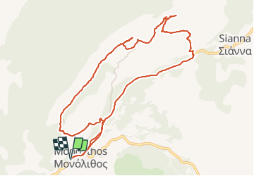

Length
13.8 km

Max alt
816 m

Uphill gradient
557 m
Km-Effort
21 km

Min alt
318 m

Downhill gradient
557 m
Boucle
Yes
Creation date :
2023-11-09 07:41:06.083
Updated on :
2023-11-09 12:27:52.942
4h21
Difficulty : Very difficult

FREE GPS app for hiking
 SityTrail
IGN / Geographical institutes
SityTrail Plus
The world is yours!
About
Trail Walking of 13.8 km to be discovered at Aegean, Rhodes Regional Unit. This trail is proposed by mrcat.
Positioning
Country:
Greece
Region :
Aegean
Department/Province :
Rhodes Regional Unit
Municipality :
Unknown
Location:
Unknown
Start:(Dec)
Start:(UTM)
566377 ; 3998673 (35S) N.
Comments