


BDO_CLF_ETAPE5_BOËN_NOIRETABLE

veyrie
User
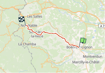

Length
27 km

Max alt
865 m

Uphill gradient
922 m
Km-Effort
38 km

Min alt
385 m

Downhill gradient
558 m
Boucle
No
Creation date :
2023-11-09 18:51:17.52
Updated on :
2025-02-24 16:33:07.728
8h39
Difficulty : Very difficult

FREE GPS app for hiking
 SityTrail
IGN / Geographical institutes
SityTrail Plus
The world is yours!
About
Trail Walking of 27 km to be discovered at Auvergne-Rhône-Alpes, Loire, Boën-sur-Lignon. This trail is proposed by veyrie.
Positioning
Country:
France
Region :
Auvergne-Rhône-Alpes
Department/Province :
Loire
Municipality :
Boën-sur-Lignon
Location:
Unknown
Start:(Dec)
Start:(UTM)
578091 ; 5066233 (31T) N.
Comments