


Cap Taillat cap Lardier

aljac
User
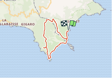

Length
13.4 km

Max alt
162 m

Uphill gradient
380 m
Km-Effort
18.5 km

Min alt
0 m

Downhill gradient
380 m
Boucle
Yes
Creation date :
2023-11-10 08:38:52.282
Updated on :
2023-11-10 13:57:03.871
5h17
Difficulty : Medium

FREE GPS app for hiking
 SityTrail
IGN / Geographical institutes
SityTrail Plus
The world is yours!
About
Trail Walking of 13.4 km to be discovered at Provence-Alpes-Côte d'Azur, Var, Ramatuelle. This trail is proposed by aljac.
Positioning
Country:
France
Region :
Provence-Alpes-Côte d'Azur
Department/Province :
Var
Municipality :
Ramatuelle
Location:
Unknown
Start:(Dec)
Start:(UTM)
308341 ; 4783824 (32T) N.
Comments