Trail Walking Esneux - 2023-11-10_18h47m33_1728.gpx.xml - Photo

2023-11-10_18h47m33_1728.gpx.xml

© OpenStreetMap contributors
Length
Length
9.8 km
Max alt
Max alt
221 m
Uphill gradient
Uphill gradient
279 m
Km-Effort
Km-Effort  
13.5 km
Min alt
Min alt
73 m
Downhill gradient
Downhill gradient
281 m
Boucle
Boucle
Yes
Creation date :
2023-11-10 17:47:33.446
Updated on :
2023-11-11 13:59:26.495

(1 Reviews)

Walking
Walking
3h04
Difficulty : Medium

Scan this QR Code to open this trail in the SityTrail application

FREE GPS app for hiking

Logo SityTrail SityTrail

IGN / Geographical institutes

Download SityTrail from the App Store Download SityTrail from Google Play

Logo SityTrail SityTrail World

The world is yours!

Download SityTrail from the App Store Download SityTrail from Google Play Download SityTrail on Huawei AppGallery

About

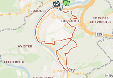
Trail Walking of 9.8 km to be discovered at Wallonia, Liège, Esneux. This trail is proposed by mumu.larandonneuse.

Description

Au sud de Liège, au début des Ardennes, se trouve la ville de Tilff.
Au cours de cette randonnée exigeante, composée de 2 boucles, vous commencez immédiatement à grimper à travers bois jusqu'au hameau de Sur Cortil.
Vous montez encore un peu et atteignez le point de vue du Grand Boubou. Par un joli sentier ardennais, vous descendez jusqu'au beau village de Méry et ici vous marchez jusqu'au pont sur l'Ourthe, d'où vous avez une belle vue. Après un autre beau tronçon le long de l'Ourthe, commence la deuxième montée jusqu'au carrefour et par un sentier pédestre vous marchez jusqu'à l'abbaye de Brialmont, où vous pourrez visiter l'église. Vous empruntez un joli sentier jusqu'à un point de vue puis descendez le sentier escarpé jusqu'à Tilff. Un joli sentier facile le long de l'Ourthe vous amène à une jolie place avec des terrasses au centre. Au bout vous passez devant le Château Brunsode.
ℹ️ www.wandelgidszuidlimburg com n° 1728.

Elevation profile

Photos

Positioning

Country:
Belgium
Region :
Wallonia
Department/Province :
Liège
Municipality :
Esneux
Location:
Tilff
Start:(UTM)
683247 ; 5605068 (31U) N.

Comments

Please log in to post a review or rate the element


Beau parcours. Une descente sportive du versant assez glissante par temps de pluie.


Trails nearby

Trail Walking Chaudfontaine - RB-Lg-21_Chaudfontaine_via-racc-1-et-2 - Photo
Walking
PRO

Walking

Difficult
(8)
Chaudfontaine, Wallonia, Liège, Belgium
11.6 km | 16.5 km-effort
3h 45min
Yes
Trail Walking Chaudfontaine - RB-Lg-21_Chaudfontaine - Photo
Walking
PRO

Walking

(13)
Chaudfontaine, Wallonia, Liège, Belgium
18 km | 26 km-effort
5h 56min
Yes
Trail Walking Esneux - RB-Lg-20_Tilff - Photo
Walking
PRO

Walking

Very difficult
(6)
Esneux, Wallonia, Liège, Belgium
20 km | 28 km-effort
6h 21min
Yes
Trail Walking Neupré - Neupré - les contreforts de la Boucle de l'Ourthe - Photo
Walking
PRO

Walking

Medium
(18)
Neupré, Wallonia, Liège, Belgium
7.9 km | 10.9 km-effort
2h 21min
Yes
Trail Walking Esneux - RB-LG-10 - Raccourci - Photo
Walking
PRO

Walking

Difficult
(6)
Esneux, Wallonia, Liège, Belgium
11 km | 15.1 km-effort
3h 26min
Yes
Trail Walking Chaudfontaine - Chaudfontaine, Natura 2000 - Des sites qui valent le détour, Lg7 - Photo
Walking
GUIDE+

Walking

Difficult
(13)
Chaudfontaine, Wallonia, Liège, Belgium
5.3 km | 8.7 km-effort
1h 48min
Yes
Trail Walking Esneux - RB-LG-10 - Au fil de l’Ourthe : la boucle de Fêchereux et au-delà - Photo
Walking
PRO

Walking

Very difficult
(21)
Esneux, Wallonia, Liège, Belgium
21 km | 29 km-effort
6h 32min
Yes
Trail Walking Neupré - Neupré - Sentier Paysage et Géologie - Photo
Walking
PRO

Walking

Easy
(8)
Neupré, Wallonia, Liège, Belgium
2.7 km | 3.6 km-effort
50min
Yes
Trail Walking Neupré - Neupré - Balade du Chemin des morts - Photo
Walking
PRO

Walking

Medium
(14)
Neupré, Wallonia, Liège, Belgium
5.1 km | 7.4 km-effort
1h 33min
Yes


Close
My subscriptions