


hautpoul

elexine23
User
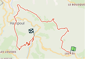

Length
13.3 km

Max alt
809 m

Uphill gradient
444 m
Km-Effort
20 km

Min alt
350 m

Downhill gradient
742 m
Boucle
No
Creation date :
2023-10-22 07:13:35.714
Updated on :
2023-11-12 07:47:24.396
3h40
Difficulty : Easy

FREE GPS app for hiking
 SityTrail
IGN / Geographical institutes
SityTrail Plus
The world is yours!
About
Trail Walking of 13.3 km to be discovered at Occitania, Tarn, Mazamet. This trail is proposed by elexine23.
Positioning
Country:
France
Region :
Occitania
Department/Province :
Tarn
Municipality :
Mazamet
Location:
Unknown
Start:(Dec)
Start:(UTM)
452892 ; 4811953 (31T) N.
Comments