


Le long du canal de la Siagne (une partie)

jwo47
User
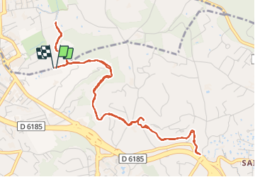

Length
6.6 km

Max alt
192 m

Uphill gradient
97 m
Km-Effort
7.9 km

Min alt
144 m

Downhill gradient
101 m
Boucle
Yes
Creation date :
2023-11-12 13:02:44.0
Updated on :
2023-11-12 14:51:39.761

FREE GPS app for hiking
 SityTrail
IGN / Geographical institutes
SityTrail Plus
The world is yours!
About
Trail of 6.6 km to be discovered at Provence-Alpes-Côte d'Azur, Maritime Alps, Mougins. This trail is proposed by jwo47.
Description
Sympa pour découvrir paysages, bois et restanques… avec un plus de 0 m….
Photos
 - Photo 1")
 - Photo 2")
 - Photo 3")
 - Photo 4")
 - Photo 5")
 - Photo 6")
 - Photo 7")
 - Photo 8")
 - Photo 9")
 - Photo 10")
Positioning
Country:
France
Region :
Provence-Alpes-Côte d'Azur
Department/Province :
Maritime Alps
Municipality :
Mougins
Location:
Unknown
Start:(Dec)
Start:(UTM)
337179 ; 4830861 (32T) N.
Comments