


sechilienne, col madeleine

lionelnottat
User
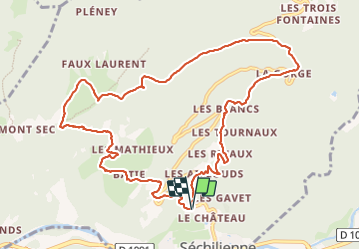

Length
12.2 km

Max alt
1268 m

Uphill gradient
860 m
Km-Effort
24 km

Min alt
408 m

Downhill gradient
859 m
Boucle
Yes
Creation date :
2023-11-14 08:33:34.291
Updated on :
2023-11-14 14:46:21.313
4h12
Difficulty : Very difficult

FREE GPS app for hiking
 SityTrail
IGN / Geographical institutes
SityTrail Plus
The world is yours!
About
Trail Walking of 12.2 km to be discovered at Auvergne-Rhône-Alpes, Isère, Séchilienne. This trail is proposed by lionelnottat.
Positioning
Country:
France
Region :
Auvergne-Rhône-Alpes
Department/Province :
Isère
Municipality :
Séchilienne
Location:
Unknown
Start:(Dec)
Start:(UTM)
722846 ; 4993354 (31T) N.
Comments